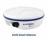
Rent a DGPS receiver for geophysicists, engineers, geologists, archaeologists, law enforcement agencies, agriculture, and the military.
A DGPS Receiver provides better resolution than uncorrected GPS. For ground control or land survey applications that require global positioning greater than common GPS. Rent a differential global positioning system or DGPS receiver from Geophysical Equipment Rental LLC. There are many different types of DGPS corrections available. There are corrections that are free to the public and commercial systems that are subscription based. While the accuracy of the fee based systems overlap with the accuracy of the DGPS public systems, non-fee based applications that require sub-meter accuracy can be achieved approximately 95% of the time for no additional charge. Hemisphere GPS states their A100 system has a horizontal accuracy of less than or equal to 0.6 meters with 95% confidence. However, the number of available satellites, their position, and other factors can control this accuracy.
How accurate is DGPS?
That depends on a comparison of the specification verses its application.
In the U.S, the Federal government developed the Wide Area Augmentation System or WAAS. It is a Space Based Augmentation Systems (SBAS) for DGPS. However, implementation or integrating WAAS into a GPS system can vary by manufacture. The WAAS specification requires it to provide a position accuracy of 7.6 metres (25 ft) or better (for both lateral and vertical measurements), at least 95% of the time. Actual performance measurements of the system at specific locations have shown it typically provides better than 1.0 meter (3 ft 3 in) laterally and 1.5 meter (4 ft 11 in) vertically throughout most of the contiguous United States and large parts of Canada and Alaska.
Who uses DGPS.
DGPS receivers are commonly used in geophysical surveys, farming, hydro-graphic surveys, archaeological studies, forensic science, forestry, and robotic controls. Geophysical surveys use DGPS for establishing grids and locations of acquired geophysical data. Agricultural applications (farming) or hydro-graphic surveys may use the technology to follow a predetermined path or to record discoveries. A geologist may use a DGPS receiver to map geology (e.g. mapping a levee). Many of the other applications use DGPS receivers to record a position. Follow this link to contact someone at DGPSReceiver.com.


